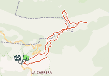
![](/images/other/stat-length.png)
![Randonnée A pied Montagut i Oix - Oix-Grau d'Escales - Photo](https://media.geolcdn.com/t/1900/400/f9abda2e-d7b1-4f67-a847-73dc649ba8e2.jpeg&format=pjpeg&maxdim=2)
Oix-Grau d'Escales
SityTrail - itinéraires balisés pédestres
Tous les sentiers balisés d’Europe GUIDE+
![Longueur](/images/other/stat-length.png)
![Altitude max](https://static1.geolcdn.com/siteimages/upload/files/1508320355ic_sort_altitude_max_24dp.png)
![Dénivelé positif](https://static1.geolcdn.com/siteimages/upload/files/1508320355ic_sort_den_pos_24dp.png)
![Km-Effort](/images/other/stat-length.png)
![Altitude min](https://static1.geolcdn.com/siteimages/upload/files/1508320355ic_sort_altitude_min_24dp.png)
![Dénivelé négatif](https://static1.geolcdn.com/siteimages/upload/files/1508320355ic_sort_den_neg_24dp.png)
![Boucle](https://static1.geolcdn.com/siteimages/upload/files/16400158638029165_repeat_loop_refresh_sync_direction_icon.png)
![A pied](https://static1.geolcdn.com/sitytour/trail-icons/100.png)
3h17
Difficulté : Facile
![Scannez ce code QR pour ouvrir la randonnée dans l'application SityTrail](https://capi.geolives.com/qq0zvz2zws4bq2lad0pu/sitytour/trails/3110435/qr.png?size=200)
Application GPS de randonnée GRATUITE
À propos
Randonnée A pied de 10,6 km à découvrir à Catalogne, Gérone, Montagut i Oix. Cette randonnée est proposée par SityTrail - itinéraires balisés pédestres.
Description
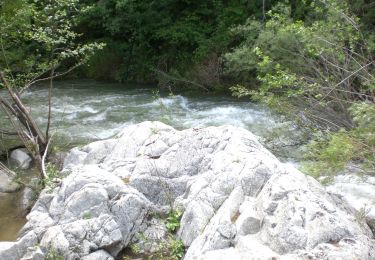
El Grau d'Escales com el nom de grau inidica, és un pas relativament planer, a manera d'esglaó o replà que travessa una costa abrupta. Des d’aquest punt podrem observar de ben a prop el Salt dels Lliberals
Site web: https://www.itinerannia.net/ca/itineraris/ruta-grau-d-escales-ruta-2-montagut-i-oix/
Localisation
Commentaires
Randonnées à proximité
![Randonnée A pied Montagut i Oix - Oix-Santa Bàrbara de Pruneres - Photo](https://media.geolcdn.com/t/375/260/cb10d5bf-5a9a-4587-8bd4-b5f3a34880cd.jpeg&format=jpg&maxdim=2)
![A pied A pied](https://static1.geolcdn.com/sitytour/trail-icons/100.png)
A pied
![](/images/other/stat-length.png)
![](https://static1.geolcdn.com/siteimages/upload/files/16400158638029165_repeat_loop_refresh_sync_direction_icon.png)
![Randonnée A pied Montagut i Oix - 186 - Photo](https://media.geolcdn.com/t/375/260/2fb22bb4-f048-4ae0-954f-9845c4c16433.jpeg&format=jpg&maxdim=2)
![A pied A pied](https://static1.geolcdn.com/sitytour/trail-icons/100.png)
![Randonnée Marche Montagut i Oix - talaixa - Photo](https://media.geolcdn.com/t/375/260/ext.jpg?maxdim=2&url=https%3A%2F%2Fstatic1.geolcdn.com%2Fsiteimages%2Fupload%2Ffiles%2F1553511878bg_sport_marche.png)
![Marche Marche](https://static1.geolcdn.com/sitytour/trail-icons/101.png)
Marche
![](/images/other/stat-length.png)
![](https://static1.geolcdn.com/siteimages/upload/files/16400158638029165_repeat_loop_refresh_sync_direction_icon.png)